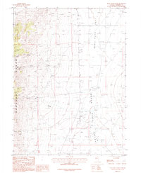
1987 Map of Star Creek Ranch
USGS Topo · Published 1987About this map
The Humboldt Range dominates the western half of this 1980s provisional survey, where steep drainages like Santa Clara Canyon and Bloody Canyon cut through the high terrain. The era's industrial activity is evident in the numerous Mine Shafts, an Adit, and several Prospects concentrated along the mountain slopes, indicating a landscape heavily shaped by mineral exploration. To the east, the topography transitions abruptly into the broad expanse of the Buena Vista Valley and Dun Glen Flat. This lowland area is characterized by sparse settlement, centered on the Star Creek Ranch and supported by infrastructure such as Landing Strips and a network of ditches. Water management in this arid environment is highlighted by the presence of Star Creek, several wells, and a Ditch system, reflecting the vital relationship between limited water resources and ranching operations in Pershing County.
Find a feature on this map
20 named features on this map. Tap any name to fly to it.
Don’t see what you’re looking for? This feature index may not catch every label — zoom into the map to look around manually.
Map Details
Editions of this 1987 Star Creek Ranch Map
This is the sole edition of this map. No revisions or reprints were ever made.
Other maps of this area

1931 · Lovelock
USGS Topo · 1:250,000

1932 · Sonoma Range
USGS Topo · 1:250,000

1935 · Lovelock
USGS Topo · 1:250,000

1939 · Sonoma Range
USGS Topo · 1:250,000

1954 · Unionville
USGS Topo · 1:62,500

1955 · Lovelock
USGS Topo · 1:250,000

1955 · Winnemucca
USGS Topo · 1:250,000

1956 · Imlay
USGS Topo · 1:62,500

1958 · Winnemucca
USGS Topo · 1:250,000

1959 · Lovelock
USGS Topo · 1:250,000