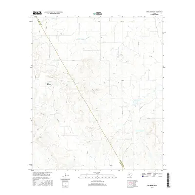
2016 Map of Star Mountain
USGS Topo · Published 2016About this map
Star Mountain and the Hog Mountains define the high ground of this Central Texas landscape along the Comanche and Brown county line. The terrain is deeply carved by a network of drainage systems, including Patridge Creek and Stag Creek, which flow toward larger catchments. Significant mid-century water management is evident through several major projects, specifically the Soil Conservation Service Site 7, Site 10, and Site 11 reservoirs. These features illustrate the regional efforts to manage runoff in a watershed dominated by intermittent streams like Little Jimmys Creek and Blanket Creek. A network of rural farm-to-market roads, such as FM 1689, FM 1477, and FM 1467, provides the primary infrastructure for the sparsely settled ranching and agricultural lands that occupy the valleys between the prominent limestone ridges.
Find a feature on this map
34 named features on this map. Tap any name to fly to it.
Don’t see what you’re looking for? This feature index may not catch every label — zoom into the map to look around manually.
Map Details
Editions of this 2016 Star Mountain Map
This is the sole edition of this map. No revisions or reprints were ever made.
Other maps of this area

1889 · Brownwood
USGS Topo · 1:125,000

1894 · Eastland
USGS Topo · 1:125,000

1894 · Brownwood
USGS Topo · 1:125,000

1954 · Brownwood
USGS Topo · 1:250,000

1954 · Abilene
USGS Topo · 1:250,000

1958 · Abilene
USGS Topo · 1:250,000
1966 · Owens
USGS Topo · 1:24,000
1966 · May
USGS Topo · 1:24,000

1966 · Star Mountain
USGS Topo · 1:24,000

1966 · Sipe Springs
USGS Topo · 1:24,000