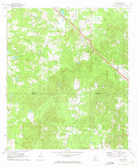
1971 Map of Star
USGS Topo · Published 1973About this map
The Illinois Central railroad cuts a diagonal path through this rural landscape in the early 1970s, serving the small community of Star. The terrain is defined by a dense network of drainage systems, including the winding courses of Mountain Creek, Hominy Creek, and Limestone Creek. This map captures a moment when the regional economy was tied to the land, evidenced by numerous Gravel Pits scattered across the countryside.
Find a feature on this map
21 named features on this map. Tap any name to fly to it.
Don’t see what you’re looking for? This feature index may not catch every label — zoom into the map to look around manually.
Map Details
Editions of this 1971 Star Map
2 editions found
Other maps of this area

1903 · Jackson
USGS Topo · 1:125,000

1906 · Florence
USGS Topo · 1:62,500

1908 · Florence
USGS Topo · 1:62,500

1953 · Hattiesburg
USGS Topo · 1:250,000

1953 · Meridian
USGS Topo · 1:250,000

1953 · Natchez
USGS Topo · 1:250,000

1955 · Jackson
USGS Topo · 1:250,000

1956 · Natchez
USGS Topo · 1:250,000

1957 · Meridian
USGS Topo · 1:250,000

1958 · Hattiesburg
USGS Topo · 1:250,000