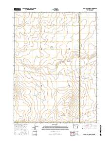
2017 Map of Star Valley Knoll
USGS Topo · Published 2017About this map
Star Valley Knoll stands as a prominent landmark in this high-desert landscape along the border of Oregon and Idaho. The map reveals a region defined by water management and drainage patterns within Malheur County, characterized by a series of high-altitude catchments like Rabbit Run Reservoir and the S Willow Creek Butte Reservoir. Movement through this remote corner of the Owyhee country is dictated by the rugged topography, with Tent Creek Rd and State and Co Line Rd providing the primary access points across the section lines. The presence of Pigeon-toe Lake and Tent Cr highlights the seasonal hydrology essential for ranching and land management in this arid transition zone between states.
Find a feature on this map
17 named features on this map. Tap any name to fly to it.
Don’t see what you’re looking for? This feature index may not catch every label — zoom into the map to look around manually.
Map Details
Editions of this 2017 Star Valley Knoll Map
This is the sole edition of this map. No revisions or reprints were ever made.
Other maps of this area

1882 · Paradise
USGS Topo · 1:250,000

1893 · Paradise
USGS Topo · 1:250,000

1955 · McDermitt
USGS Topo · 1:250,000

1955 · Jordan Valley
USGS Topo · 1:250,000

1957 · Jordan Valley
USGS Topo · 1:250,000

1958 · Jordan Valley
USGS Topo · 1:250,000

1959 · McDermitt
USGS Topo · 1:250,000

1973 · Spring Creek Basin
USGS Topo · 1:24,000
1973 · Star Valley
USGS Topo · 1:24,000
1973 · Star Valley Ridge West
USGS Topo · 1:24,000