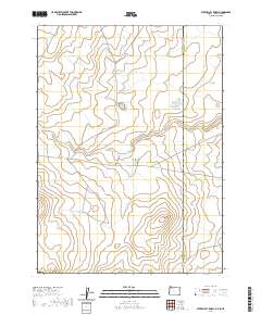
2020 Map of Star Valley Knoll
USGS Topo · Published 2020About this map
Star Valley Knoll stands as a prominent elevation in this high-desert region of Malheur County, where the state line with Idaho marks the eastern boundary. The landscape is defined by its water management infrastructure, featuring several catchment areas including Rabbit Run Reservoir, East Side Reservoir, and South Willow Cr Butte Reservoir. These engineered water sources highlight the importance of moisture retention in a region where natural drainages like Tent Cr and South Willow Creek are intermittent. Tent Creek Rd serves as the primary corridor through this open range, connecting remote parcels across multiple township and range sections. The presence of Pigeon-toe Lake suggests a unique natural depression in the plateau, providing a stark contrast to the surrounding topography near the borderlands.
Find a feature on this map
17 named features on this map. Tap any name to fly to it.
Don’t see what you’re looking for? This feature index may not catch every label — zoom into the map to look around manually.
Map Details
Editions of this 2020 Star Valley Knoll Map
This is the sole edition of this map. No revisions or reprints were ever made.
Other maps of this area

1882 · Paradise
USGS Topo · 1:250,000

1893 · Paradise
USGS Topo · 1:250,000

1955 · McDermitt
USGS Topo · 1:250,000

1955 · Jordan Valley
USGS Topo · 1:250,000

1957 · Jordan Valley
USGS Topo · 1:250,000

1958 · Jordan Valley
USGS Topo · 1:250,000

1959 · McDermitt
USGS Topo · 1:250,000

1973 · Spring Creek Basin
USGS Topo · 1:24,000
1973 · Star Valley
USGS Topo · 1:24,000
1973 · Star Valley Ridge West
USGS Topo · 1:24,000