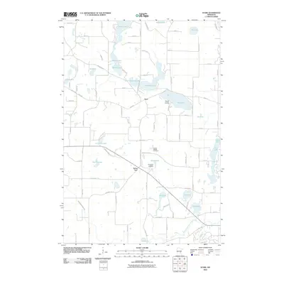
2010 Map of Stark
USGS Topo · Published 2010About this map
The settlement of Stark anchors this rural Chisago County landscape, which is defined by an intricate cluster of glacial lakes and wetlands. The community's spiritual and family history is centered on the Spring Lake Lutheran Cemetery and Fish Lake Lutheran Cemetery, serving as vital records for local genealogy. The terrain is dominated by water bodies such as Big Pine Lake, Goose Lake, and the winding North Branch Sunrise River at the southern edge. The distribution of homes and farmsteads follows a grid of secondary roads like Stark Rd and County Hwy 65, which connect the various lakefronts. To the east of Spring Lake, the Trulson Wildlife Pond Dam indicates managed water levels within this pond-rich region. The map illustrates a contemporary rural character where traditional agriculture and newer residential footprints meet the many shorelines of Horseshoe Lake and Mandall Lake.
Find a feature on this map
84 named features on this map. Tap any name to fly to it.
Don’t see what you’re looking for? This feature index may not catch every label — zoom into the map to look around manually.
Map Details
Editions of this 2010 Stark Map
This is the sole edition of this map. No revisions or reprints were ever made.
Other maps of this area

1950 · Rush City
USGS Topo · 1:48,000

1953 · Stillwater
USGS Topo · 1:250,000

1955 · Rush City
USGS Topo · 1:62,500

1955 · Forest Lake
USGS Topo · 1:62,500

1955 · Isanti
USGS Topo · 1:62,500

1955 · Stillwater
USGS Topo · 1:250,000

1958 · Stillwater
USGS Topo · 1:250,000

1961 · Cambridge
USGS Topo · 1:62,500

1965 · Stillwater
USGS Topo · 1:250,000
1974 · Stacy
USGS Topo · 1:24,000