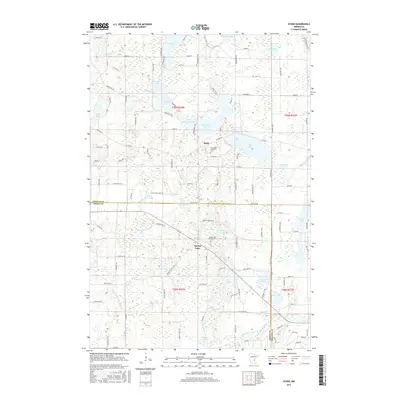
2016 Map of Stark
USGS Topo · Published 2016About this map
The small settlement of Stark anchors this portion of eastern Minnesota, situated on the western shore of Fish Lake. The landscape is defined by its glacial heritage, characterized by a dense network of water bodies including Goose Lake, Spring Lake, and the uniquely named Little Horseshoe Lake. Agricultural and residential development is structured by a rigorous township and range system, with the Chisago Co Isanti Co boundary dividing the area. Genealogical interest is centered on the Fish Lake Lutheran Cem and Spring Lake Lutheran Cem, which reflect the Scandinavian heritage common to this region. Water management is evident through features like Judicial Ditch Number Four, while the Br Sunrise River provides natural drainage for the numerous wetlands and smaller lakes like Mandall Lake and Rat Lake.
Find a feature on this map
73 named features on this map. Tap any name to fly to it.
Don’t see what you’re looking for? This feature index may not catch every label — zoom into the map to look around manually.
Map Details
Editions of this 2016 Stark Map
This is the sole edition of this map. No revisions or reprints were ever made.
Other maps of this area

1950 · Rush City
USGS Topo · 1:48,000

1953 · Stillwater
USGS Topo · 1:250,000

1955 · Rush City
USGS Topo · 1:62,500

1955 · Forest Lake
USGS Topo · 1:62,500

1955 · Isanti
USGS Topo · 1:62,500

1955 · Stillwater
USGS Topo · 1:250,000

1958 · Stillwater
USGS Topo · 1:250,000

1961 · Cambridge
USGS Topo · 1:62,500

1965 · Stillwater
USGS Topo · 1:250,000
1974 · Stacy
USGS Topo · 1:24,000