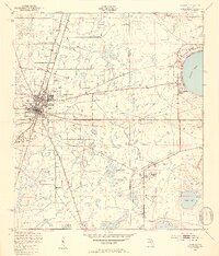
1949 Map of Starke
USGS Topo · Published 1953About this map
Starke serves as the central hub of this 1949 survey, situated along the Seaboard Air Line railroad corridor. The landscape transitions from the developed grid of the town to the wetlands and pine lands of the Florida interior, where small communities like Lincoln City and Kingsley Village are established. To the east, the map reveals the industrial and military footprint of the era, notably the Trail Ridge Mine and the Mobile Target Range, indicating the significant shift toward mineral extraction and defense preparations during the mid-century period.
Find a feature on this map
20 named features on this map. Tap any name to fly to it.
Don’t see what you’re looking for? This feature index may not catch every label — zoom into the map to look around manually.
Map Details
Editions of this 1949 Starke Map
4 editions found

Other maps of this area

1918 · Middleburg
USGS Topo · 1:62,500

1918 · Lawtey
USGS Topo · 1:62,500

1941 · Starke
USGS Topo · 1:62,500

1941 · Middleburg
USGS Topo · 1:62,500

1942 · Ates Creek
USGS Topo · 1:62,500

1948 · Starke
USGS Topo · 1:50,000

1948 · Jacksonville
USGS Topo · 1:250,000

1949 · Middleburg SW
USGS Topo · 1:24,000

1949 · Sampson
USGS Topo · 1:24,000

1949 · Gold Head Branch
USGS Topo · 1:24,000