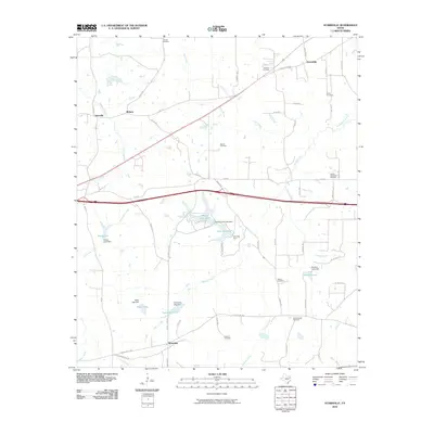
2010 Map of Starrville
USGS Topo · Published 2010About this map
Starrville and the nearby community of Friendship define this portion of the Texas Piney Woods at the start of the 21st century. The landscape is a network of small watersheds where Rice Creek, Simpson Creek, and Prairie Creek feed into a series of localized reservoirs, including Howell Club Lake and Hamrick Lake. Industry remains a quiet but present force here, represented by the Wright Mountain Oil Field in the eastern section of the quadrangle. For those researching family history, the map is remarkably dense with burial grounds, documenting several named cemeteries like Old Hopewell Cemetery, Siloam Cemetery, and Pinkston Cemetery. The road network, including Old Kilgore Hwy and Jackson Marshall Rd, illustrates the persistent rural infrastructure connecting these historic settlements and family lands.
Find a feature on this map
68 named features on this map. Tap any name to fly to it.
Don’t see what you’re looking for? This feature index may not catch every label — zoom into the map to look around manually.
Map Details
Editions of this 2010 Starrville Map
This is the sole edition of this map. No revisions or reprints were ever made.
Other maps of this area

1936 · Kilgore
USGS Topo · 1:48,000

1938 · Winona
USGS Topo · 1:48,000

1940 · Kilgore
USGS Topo · 1:62,500

1943 · Winona
USGS Topo · 1:62,500

1956 · Tyler
USGS Topo · 1:250,000

1960 · Hawkins
USGS Topo · 1:24,000

1960 · Big Sandy
USGS Topo · 1:24,000

1960 · Gladewater
USGS Topo · 1:24,000

1966 · Hope Pond
USGS Topo · 1:24,000
1966 · Starrville
USGS Topo · 1:24,000