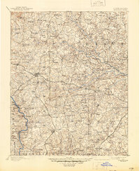
1893 Map of Statesville
USGS Topo · Published 1945About this map
Statesville and Mocksville anchor this landscape during the late nineteenth century, serving as critical hubs where the Piedmont's rural mill economy met the growing power of steam transport. Three major rail lines, including the Western North Carolina Railroad and the North Carolina Railroad, intersect the region, facilitating the movement of goods from a dense network of water-powered enterprises like Harmons Mill, Morrisons Mill, and Files Mill.
Find a feature on this map
136 named features on this map. Tap any name to fly to it.
Don’t see what you’re looking for? This feature index may not catch every label — zoom into the map to look around manually.
Map Details
Editions of this 1893 Statesville Map
2 editions found
Other maps of this area

1889 · Wilkesboro
USGS Topo · 1:125,000

1891 · Wilkesboro
USGS Topo · 1:125,000

1891 · Yadkinville
USGS Topo · 1:125,000

1893 · Statesville
USGS Topo · 1:125,000

1893 · Yadkinville
USGS Topo · 1:125,000

1895 · Hickory
USGS Topo · 1:125,000

1914 · Gastonia
USGS Topo · 1:48,000

1916 · Gastonia
USGS Topo · 1:62,500

1941 · Charlotte
USGS Topo · 1:125,000

1942 · Charlotte
USGS Topo · 1:125,000