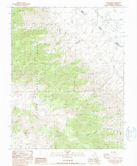
1987 Map of Station Peak
USGS Topo · Published 1987About this map
Inyo National Forest dominates this high-altitude landscape, where the peaks of the White Mountains meet the arid floor of Fish Lake Valley. The map documents the high-desert borderlands between Mono County and Esmeralda County, defined by the historic Von Schmidt Line which separates California and Nevada. Human activity is focused on the periphery of the forest, notably at the Deep Springs Cow Camp and a remote Landing Strip near the valley floor. Water sources are critical in this environment, indicated by numerous springs and drainage systems like Furnace Creek, Cottonwood Creek, and Indian Garden Creek. Topographically, the area is anchored by Station Peak and Red Mountain, while several labeled Prospect locations and a Borrow Pit hint at the region's sparse industrial and mining history.
Find a feature on this map
20 named features on this map. Tap any name to fly to it.
Don’t see what you’re looking for? This feature index may not catch every label — zoom into the map to look around manually.
Map Details
Editions of this 1987 Station Peak Map
This is the sole edition of this map. No revisions or reprints were ever made.
Other maps of this area

1898 · Silver Peak
USGS Topo · 1:125,000

1900 · Silver Peak
USGS Topo · 1:125,000

1908 · Lida
USGS Topo · 1:250,000

1913 · Bishop
USGS Topo · 1:125,000

1913 · Lida
USGS Topo · 1:250,000

1917 · White Mountain
USGS Topo · 1:125,000

1947 · Mariposa
USGS Topo · 1:250,000

1948 · Mariposa
USGS Topo · 1:250,000

1951 · Blanco Mountain
USGS Topo · 1:62,500

1954 · Goldfield
USGS Topo · 1:250,000