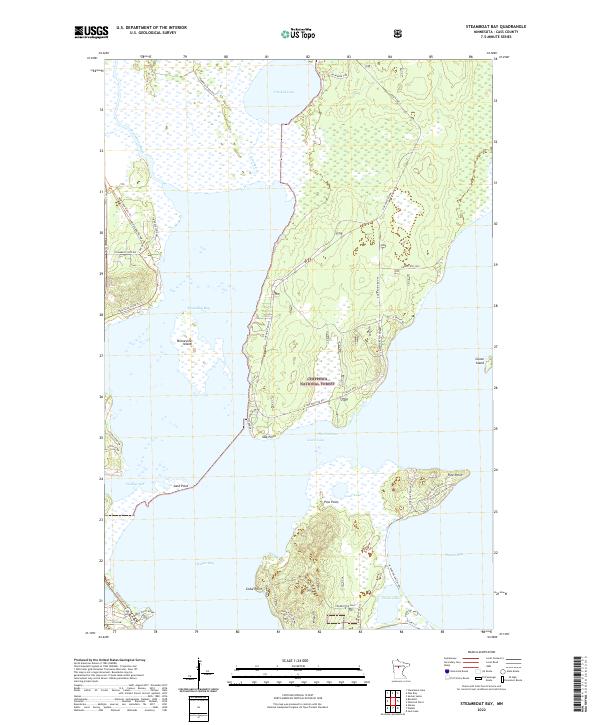
2022 Map of Steamboat Bay
USGS Topo · Published 2022About this map
Leech Lake and its intricate northern bays define this portion of the Chippewa National Forest, where water and land form a complex mosaic of points and islands. The map details the transition from the Steamboat River into Steamboat Bay, passing Minnesota Island as it opens toward The Narrows. Significant recreational and transit corridors like the Heartland State Trl and various forest routes, including Oak Point Rd NW, navigate the heavily wooded peninsulas of Oak Point and Pine Point. This 2022 survey illustrates the modern configuration of the shoreline and internal water bodies such as Crooked Lake and Gould Lake, showing how access roads like Morris Point Rd NW serve the developed edges of Walker Bay and Traders Bay.
Find a feature on this map
48 named features on this map. Tap any name to fly to it.
Don’t see what you’re looking for? This feature index may not catch every label — zoom into the map to look around manually.
Map Details
Editions of this 2022 Steamboat Bay Map
This is the sole edition of this map. No revisions or reprints were ever made.
Other maps of this area

1954 · Bemidji
USGS Topo · 1:250,000

1957 · Bemidji
USGS Topo · 1:250,000

1958 · Bemidji
USGS Topo · 1:250,000
1971 · Jack Lake
USGS Topo · 1:24,000

1971 · Sucker Lakes
USGS Topo · 1:24,000
1971 · Ottertail Point
USGS Topo · 1:24,000

1972 · Steamboat Bay
USGS Topo · 1:24,000

1972 · Benedict
USGS Topo · 1:24,000

1972 · Pike Bay
USGS Topo · 1:24,000
1972 · Akeley
USGS Topo · 1:24,000