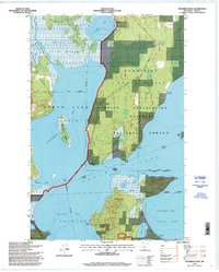
1996 Map of Steamboat Bay
USGS Topo · Published 1998About this map
The Chippewa Indian Reservation occupies a significant portion of this landscape, where the waters of Leech Lake meet complex shorelines and islands. The map details the transition between various protected lands, including the Chippewa National Forest, Bowstring State Forest, and the Welsh Lake State Forest. Of particular interest to conservationists is the Pine Point Natural Area situated on a prominent peninsula. Transport and recreation are visible through the Heartland Trail and several water-access points. The hydrography is intricately mapped, showing the Steamboat River feeding into Steamboat Bay, as well as internal water features like Crooked Lake and the Roosevelt Canal. Local industry and land use are indicated by the presence of Gravel Pits and the Ranger Trail, reflecting the region's forestry and resource management heritage.
Find a feature on this map
36 named features on this map. Tap any name to fly to it.
Don’t see what you’re looking for? This feature index may not catch every label — zoom into the map to look around manually.
Map Details
Editions of this 1996 Steamboat Bay Map
This is the sole edition of this map. No revisions or reprints were ever made.
Other maps of this area

1954 · Bemidji
USGS Topo · 1:250,000

1957 · Bemidji
USGS Topo · 1:250,000

1958 · Bemidji
USGS Topo · 1:250,000
1971 · Jack Lake
USGS Topo · 1:24,000

1971 · Sucker Lakes
USGS Topo · 1:24,000
1971 · Ottertail Point
USGS Topo · 1:24,000

1972 · Steamboat Bay
USGS Topo · 1:24,000

1972 · Benedict
USGS Topo · 1:24,000

1972 · Pike Bay
USGS Topo · 1:24,000
1972 · Akeley
USGS Topo · 1:24,000