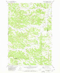
1980 Map of Steamboat Butte
USGS Topo · Published 1980About this map
Steamboat Butte dominates the southern portion of this landscape, rising above a network of drainages that define the boundary between Musselshell County and Yellowstone County. The terrain is characterized by the complex branching of Hawk Creek and the Dry Fork Hawk Creek, which carve through the high plains of central Montana. This 1980 edition reveals a sparse but industrially active landscape, marked by numerous wells and a specific Drill Hole in the northwestern corner, indicating exploratory energy activity during the era. Small water sources like Shovel Creek and scattered springs provide the primary geographic landmarks in a region defined more by its geological contours and ranching potential than by concentrated settlement. The map serves as a precise record of late 20th-century land use where county lines and hydrological features were the most prominent markers of territory.
Find a feature on this map
9 named features on this map. Tap any name to fly to it.
Don’t see what you’re looking for? This feature index may not catch every label — zoom into the map to look around manually.
Map Details
Editions of this 1980 Steamboat Butte Map
This is the sole edition of this map. No revisions or reprints were ever made.
Other maps of this area

1954 · Forsyth
USGS Topo · 1:250,000

1954 · Roundup
USGS Topo · 1:250,000

1957 · Forsyth
USGS Topo · 1:250,000

1958 · Roundup
USGS Topo · 1:250,000

1958 · Forsyth
USGS Topo · 1:250,000

1979 · Roundup
USGS Topo · 1:100,000

1979 · Corey Flat
USGS Topo · 1:24,000

1979 · Hysham
USGS Topo · 1:100,000

1979 · Chimney Butte
USGS Topo · 1:24,000
1980 · P K Ranch NE
USGS Topo · 1:24,000