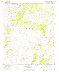
1972 Map of Steamboat Canyon
USGS Topo · Published 1975About this map
Steamboat marks the northern edge of this high-desert landscape within the Navajo Indian Reservation. The geography is defined by the steep-walled Steamboat Canyon and shifting Sand Dunes that cut across the arid plateau. Surveyed in the early 1970s, the map reveals a sparsely settled region where essential water sources like Joseph Spring and Toh Nalen served as vital nodes for local inhabitants. An Indefinite Boundary separates Apache and Navajo Counties, reflecting the complex administrative history of the high country during this era. The presence of a Sewage Disposal Pond and a Water Tank near the main settlement indicates the infrastructure supporting the community as it transitioned through the mid-20th century.
Find a feature on this map
11 named features on this map. Tap any name to fly to it.
Don’t see what you’re looking for? This feature index may not catch every label — zoom into the map to look around manually.
Map Details
Editions of this 1972 Steamboat Canyon Map
This is the sole edition of this map. No revisions or reprints were ever made.
Other maps of this area

1886 · Fort Defiance
USGS Topo · 1:250,000

1892 · Fort Defiance
USGS Topo · 1:250,000

1954 · Gallup
USGS Topo · 1:250,000

1958 · Gallup
USGS Topo · 1:250,000

1959 · Gallup
USGS Topo · 1:250,000

1962 · Gallup
USGS Topo · 1:250,000

1967 · Gallup
USGS Topo · 1:250,000
1972 · Toyei School
USGS Topo · 1:24,000
1972 · Greasewood
USGS Topo · 1:24,000
1972 · Ganado Mesa SW
USGS Topo · 1:24,000