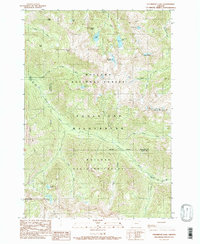
1990 Map of Steamboat Lake
USGS Topo · Published 1990About this map
The Minam River flows through the center of this high-elevation landscape, where the Wallowa National Forest meets the Whitman National Forest. This 1990 survey provides a detailed view of the Eagle Cap Wilderness and its collection of subalpine basins, including the namesake Steamboat Lake and the nearby Catched Two Lake. The topographic relief is defined by sharp peaks and ridges, most notably Glacier Mountain and the prominent China Cap Ridge. The map documents a complex drainage system where Elkhorn Creek, Copper Creek, and Wild Sheep Creek carve through the granite terrain. The absence of roads underscores the area's protected status, with only a solitary Trail network providing access to remote sites like Tombstone Lake and Swamp Lake at the foot of Elkhorn Peak.
Find a feature on this map
36 named features on this map. Tap any name to fly to it.
Don’t see what you’re looking for? This feature index may not catch every label — zoom into the map to look around manually.
Map Details
Editions of this 1990 Steamboat Lake Map
This is the sole edition of this map. No revisions or reprints were ever made.
Other maps of this area

1906 · Telocaset
USGS Topo · 1:125,000

1954 · Eagle Cap
USGS Topo · 1:62,500

1955 · Grangeville
USGS Topo · 1:250,000

1957 · Enterprise
USGS Topo · 1:62,500

1959 · Grangeville
USGS Topo · 1:250,000

1965 · China Cap
USGS Topo · 1:24,000

1965 · Flagstaff Butte
USGS Topo · 1:24,000
1966 · Jim White Ridge
USGS Topo · 1:24,000

1986 · Enterprise
USGS Topo · 1:100,000
1990 · Krag Peak
USGS Topo · 1:24,000