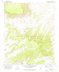
1972 Map of Steamboat Rock
USGS Topo · Published 1976About this map
The Navajo Indian Reservation landscape is defined here by the towering heights of Balaka Mesa and the prominent Steamboat Rock. This 1972 field-checked survey reveals a territory where life centers on water and geography, with remote outposts like Tsintaa Yiti Ii and essential landmarks such as Lone Pine Spring and Pine Wells providing vital resources in a dry environment. The topography is deeply carved by the Steamboat Canyon, which runs alongside a section of Highway 264, the primary transit artery through the high desert.
Find a feature on this map
16 named features on this map. Tap any name to fly to it.
Don’t see what you’re looking for? This feature index may not catch every label — zoom into the map to look around manually.
Map Details
Editions of this 1972 Steamboat Rock Map
This is the sole edition of this map. No revisions or reprints were ever made.
Other maps of this area

1886 · Fort Defiance
USGS Topo · 1:250,000

1892 · Fort Defiance
USGS Topo · 1:250,000

1954 · Gallup
USGS Topo · 1:250,000

1958 · Gallup
USGS Topo · 1:250,000

1959 · Gallup
USGS Topo · 1:250,000

1962 · Gallup
USGS Topo · 1:250,000

1967 · Gallup
USGS Topo · 1:250,000
1972 · Steamboat Canyon
USGS Topo · 1:24,000
1972 · Tolani
USGS Topo · 1:24,000
1972 · Toyei School
USGS Topo · 1:24,000