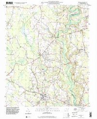
1997 Map of Stedman
USGS Topo · Published 2000About this map
The South River serves as the dividing line between Cumberland Co and Sampson Co, carving a path through a landscape defined by low-lying wetlands and established rural communities. This survey reveals a high density of country churches and family-named landmarks, reflecting a deeply rooted social fabric. Clusters of activity center around Stedman and Bethany Crossroads, while smaller points like Clement and Autryville anchor the surrounding farmlands.
Find a feature on this map
41 named features on this map. Tap any name to fly to it.
Don’t see what you’re looking for? This feature index may not catch every label — zoom into the map to look around manually.
Map Details
Editions of this 1997 Stedman Map
This is the sole edition of this map. No revisions or reprints were ever made.
Other maps of this area

1948 · Fayetteville
USGS Topo · 1:62,500

1948 · Slocomb
USGS Topo · 1:24,000

1949 · Vander
USGS Topo · 1:24,000

1950 · Slocomb
USGS Topo · 1:24,000

1953 · Florence
USGS Topo · 1:250,000

1953 · Raleigh
USGS Topo · 1:250,000

1954 · Florence
USGS Topo · 1:250,000

1954 · Raleigh
USGS Topo · 1:250,000

1957 · Vander
USGS Topo · 1:24,000

1957 · Fayetteville
USGS Topo · 1:62,500