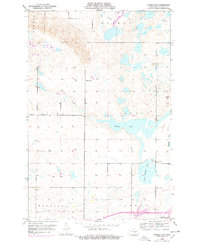
1952 Map of Steele NE
USGS Topo · Published 1978About this map
Buffalo Lake and the interconnected wetlands of the Prairie Pothole Region dominate this landscape in central North Dakota. Mapping by the U.S. Geological Survey and the State of North Dakota reveals a rural landscape organized by townships such as Allen, Vernon, and Sibley. Local community centers of the early 1950s are preserved here, including School No 1 and School No 2, along with the Allen Cem. To the southeast, the settlement of Dawson sits near the edges of Dead Buffalo Lake and Big Muddy Lake, illustrating the close relationship between pioneer-era development and the area's complex hydrology. The map provides a precise record of section lines and township roads that served the local ranching and farming economy during this post-war period.
Find a feature on this map
20 named features on this map. Tap any name to fly to it.
Don’t see what you’re looking for? This feature index may not catch every label — zoom into the map to look around manually.
Map Details
Editions of this 1952 Steele NE Map
2 editions found
Other maps of this area

1952 · Tappen South
USGS Topo · 1:24,000

1952 · Dawson
USGS Topo · 1:24,000

1952 · Tappen North
USGS Topo · 1:24,000

1952 · Steele NE
USGS Topo · 1:24,000

1952 · Steele
USGS Topo · 1:24,000

1952 · Steele NW
USGS Topo · 1:24,000

1952 · New Rockford
USGS Topo · 1:250,000

1953 · Jamestown
USGS Topo · 1:250,000

1956 · New Rockford
USGS Topo · 1:250,000

1956 · Jamestown
USGS Topo · 1:250,000