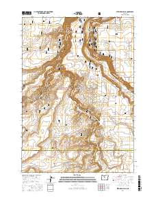
2017 Map of Steelhead Falls
USGS Topo · Published 2017About this map
The Deschutes River and Crooked River converge within a landscape of dramatic vertical relief, where high desert plateaus are severed by deep basalt canyons. This 2017 survey details the complex geology of the Crooked River National Grassland, highlighting distinctive landforms such as The Peninsula and the sheer walls of the Crooked River Gorge. The area's hydrology is marked by the presence of Opal Springs and the namesake Steelhead Falls, points where the river systems drop through the arid terrain.
Find a feature on this map
56 named features on this map. Tap any name to fly to it.
Don’t see what you’re looking for? This feature index may not catch every label — zoom into the map to look around manually.
Map Details
Editions of this 2017 Steelhead Falls Map
This is the sole edition of this map. No revisions or reprints were ever made.
Other maps of this area

1926 · Bend
USGS Topo · 1:125,000

1928 · Madras
USGS Topo · 1:125,000

1929 · Bend
USGS Topo · 1:125,000

1931 · Madras
USGS Topo · 1:125,000

1955 · Bend
USGS Topo · 1:250,000

1957 · Bend
USGS Topo · 1:250,000

1958 · Bend
USGS Topo · 1:250,000

1961 · Redmond
USGS Topo · 1:24,000

1962 · Opal City
USGS Topo · 1:24,000

1962 · Fly Creek
USGS Topo · 1:24,000