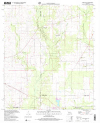
1997 Map of Steep Gully
USGS Topo · Published 2001About this map
Tenmile Creek and its tributaries define the rural landscape of south-central Louisiana in this late-twentieth-century study of the boundary lands between Vernon, Rapides, and Allen Parishes. The area is characterized by a network of country churches and small community hubs, notably the twin sites of Occupy Ch No 1 and Occupy Ch No 2, alongside Shady Grove Ch and Pine Grove Ch. These cultural markers, paired with family and community burial grounds like Tenmile Cem and West Cem, offer a clear view of the region's social geography.
Find a feature on this map
23 named features on this map. Tap any name to fly to it.
Don’t see what you’re looking for? This feature index may not catch every label — zoom into the map to look around manually.
Map Details
Editions of this 1997 Steep Gully Map
This is the sole edition of this map. No revisions or reprints were ever made.
Other maps of this area

1935 · Pawnee
USGS Topo · 1:31,680

1935 · Oakdale
USGS Topo · 1:31,680

1942 · Oakdale
USGS Topo · 1:62,500

1943 · Leander
USGS Topo · 1:62,500

1947 · Steep Gully
USGS Topo · 1:31,680

1947 · Elizabeth
USGS Topo · 1:31,680

1947 · Grant
USGS Topo · 1:31,680

1947 · Pitkin
USGS Topo · 1:31,680

1948 · Grant
USGS Topo · 1:24,000

1948 · Elizabeth
USGS Topo · 1:24,000