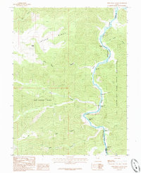
1985 Map of Steer Ridge Canyon
USGS Topo · Published 1985About this map
The Green River carves a deep, winding path through this corner of Carbon and Uintah counties, forming the primary geographic anchor for the region. Along its course, a succession of river features including Wild Horse Rapids, Steer Ridge Rapids, and Log Cabin Rapids indicate the challenging water navigation through this canyon country. The eastern bank of the river falls within the Uintah and Ouray Indian Reservation, marked by the Desolation Boundary. Significant high-elevation features like Steer Ridge and Van Duesen Ridge rise above the waterway, while the remote Johnson Spring provides a rare water source in the higher terrain. This mid-1980s data highlights the isolation of the landscape, defined by named canyons such as Calf Canyon and Snap Canyon that drain toward the river.
Find a feature on this map
23 named features on this map. Tap any name to fly to it.
Don’t see what you’re looking for? This feature index may not catch every label — zoom into the map to look around manually.
Map Details
Editions of this 1985 Steer Ridge Canyon Map
This is the sole edition of this map. No revisions or reprints were ever made.
Other maps of this area

1885 · East Tavaputs
USGS Topo · 1:250,000

1886 · Price River
USGS Topo · 1:250,000

1896 · Price River
USGS Topo · 1:250,000

1953 · Firewater Canyon
USGS Topo · 1:62,500

1954 · Flat Canyon
USGS Topo · 1:62,500

1954 · Range Creek
USGS Topo · 1:62,500

1956 · Price
USGS Topo · 1:250,000

1956 · Grand Junction
USGS Topo · 1:250,000

1959 · Grand Junction
USGS Topo · 1:250,000

1960 · Price
USGS Topo · 1:250,000