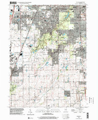
1998 Map of Steger
USGS Topo · Published 2002About this map
Governors State University serves as a major landmark on the border between University Park and Monee, representing the southward expansion of the Chicago metropolitan area's educational infrastructure. The landscape is characterized by a significant network of public lands, including the Sauk Trail County Forest Preserve and the Thorn Creek County Forest Preserve, which protect local waterways like Thorn Creek and Deer Creek. These green corridors provide a sharp contrast to the dense suburban grids of Steger and Chicago Heights to the north.
Find a feature on this map
77 named features on this map. Tap any name to fly to it.
Don’t see what you’re looking for? This feature index may not catch every label — zoom into the map to look around manually.
Map Details
Editions of this 1998 Steger Map
This is the sole edition of this map. No revisions or reprints were ever made.
Other maps of this area

1890 · Des Plaines
USGS Topo · 1:62,500

1892 · Calumet
USGS Topo · 1:62,500

1893 · Calumet
USGS Topo · 1:62,500

1894 · Des Plaines
USGS Topo · 1:62,500

1900 · Des Plaines
USGS Topo · 1:62,500

1900 · Calumet
USGS Topo · 1:62,500

1901 · Calumet
USGS Topo · 1:62,500

1901 · Des Plaines
USGS Topo · 1:62,500

1929 · Tinley Park
USGS Topo · 1:24,000

1929 · Calumet City
USGS Topo · 1:24,000