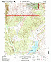
1996 Map of Steinaker Reservoir
USGS Topo · Published 1999About this map
Steinaker Reservoir serves as the central focal point of this landscape, flanked by the Steinaker State Park and the expansive reach of the Ashley National Forest. The geography is defined by a sophisticated water management system necessary for the arid terrain, featuring the Steinaker Feeder Canal, Steinaker Service Canal, and the Highline Canal. Evidence of earlier human movement is preserved in the Carter Military Trail, which winds south from Red Mountain. The presence of Petroglyphs near Ashley Creek suggests a deep history of occupation long before the establishment of modern infrastructure. Small-scale ranching and agriculture are indicated by scattered features like Spring Creek Corral and the Upper Canal, while the topography transitions from the depths of Ashley Gorge to the heights of Coal Mine Basin.
Find a feature on this map
45 named features on this map. Tap any name to fly to it.
Don’t see what you’re looking for? This feature index may not catch every label — zoom into the map to look around manually.
Map Details
Editions of this 1996 Steinaker Reservoir Map
This is the sole edition of this map. No revisions or reprints were ever made.
Other maps of this area

1885 · Ashley
USGS Topo · 1:250,000

1906 · Marsh Peak
USGS Topo · 1:125,000

1907 · Jensen
USGS Topo · 1:125,000

1908 · Marsh Peak
USGS Topo · 1:125,000

1910 · Jensen
USGS Topo · 1:125,000

1917 · Vernal
USGS Topo · 1:125,000

1950 · Burnt Cabin Gorge
USGS Topo · 1:24,000

1950 · Dyer Mountain
USGS Topo · 1:24,000

1954 · Vernal
USGS Topo · 1:250,000

1958 · Vernal
USGS Topo · 1:250,000