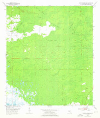
1954 Map of Steinhatchee SE
USGS Topo · Published 1976About this map
Butler Cem stands as a primary genealogical landmark in this coastal region of Dixie County, situated in the southeast corner of the quadrangle. The landscape is defined by an intricate network of wetlands, where Bear Bay Swamp and Blue Lake Swamp dominate the central interior. This mid-century survey illustrates the primitive drainage patterns of the Florida Gulf Coast before significant modern alterations, showing the natural transition from inland swamps to the Gulf of Mexico. Smaller features like Tiger Boy and Cedar Swamp emphasize the dense, water-heavy character of the terrain. The presence of Rocky Creek in the north and the southern reaches of Little Rock Swamp indicates a territory defined by seasonal inundation and limited road access, with only route 351 providing a corridor through the timber and wetlands.
Find a feature on this map
10 named features on this map. Tap any name to fly to it.
Don’t see what you’re looking for? This feature index may not catch every label — zoom into the map to look around manually.
Map Details
Editions of this 1954 Steinhatchee SE Map
4 editions found
Other maps of this area

1954 · Steinhatchee SW
USGS Topo · 1:24,000

1954 · Cross City West
USGS Topo · 1:24,000

1954 · Jena
USGS Topo · 1:24,000

1954 · Steinhatchee
USGS Topo · 1:24,000

1954 · Steinhatchee SE
USGS Topo · 1:24,000

1954 · Cross City SW
USGS Topo · 1:24,000

1954 · Horseshoe Beach
USGS Topo · 1:24,000

1954 · Gainesville
USGS Topo · 1:250,000

1955 · Shired Island
USGS Topo · 1:24,000

1958 · Gainesville
USGS Topo · 1:250,000