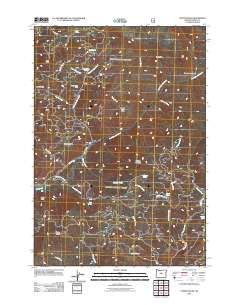
2011 Map of Steins Pillar
USGS Topo · Published 2011About this map
Steins Pillar and the Twin Pillars dominate the skyline of this Crook County landscape, defining a terrain shaped by the complex drainage of Mill Creek and its many forks. This 2011 survey reveals a forest-service environment where remote outposts like Cayuse Forest Camp and the small settlement of Barney provide rare human focal points among the ridges. The map meticulously traces a network of resource roads including Summit Rd and Mc Kay Creek Rd, which provide access to high-elevation features like Forked Horn Butte and Wildcat Mountain. Numerous named water sources, such as Jesse Spring, Pothole Spring, and White Rock Spring, suggest the critical importance of water management in this arid mountain geography. Genealogists and local historians can use the specific placement of these springs and the transition into Desolation Canyon to understand early land use and backcountry navigation in the region.
Find a feature on this map
39 named features on this map. Tap any name to fly to it.
Don’t see what you’re looking for? This feature index may not catch every label — zoom into the map to look around manually.
Map Details
Editions of this 2011 Steins Pillar Map
This is the sole edition of this map. No revisions or reprints were ever made.
Other maps of this area

1926 · Mitchell
USGS Topo · 1:125,000

1948 · Ochoco Reservoir
USGS Topo · 1:62,500

1950 · Ochoco Reservoir
USGS Topo · 1:62,500

1951 · Lookout Mtn
USGS Topo · 1:62,500

1955 · Bend
USGS Topo · 1:250,000

1957 · Bend
USGS Topo · 1:250,000

1958 · Bend
USGS Topo · 1:250,000

1968 · Dutchman Creek
USGS Topo · 1:24,000

1968 · Stephenson Mtn
USGS Topo · 1:24,000

1968 · Opal Mountain
USGS Topo · 1:24,000