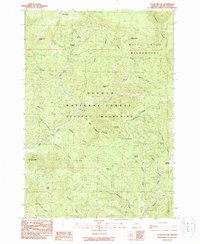
1990 Map of Steins Pillar
USGS Topo · Published 1990About this map
Ochogo National Forest dominates this Central Oregon landscape, characterized by high-elevation peaks and a network of spring-fed drainage systems. The Mill Creek Wilderness occupies the northern sector, featuring landmark formations like Twin Pillars and Hash Rock. This 1980s-era fieldwork reveals a terrain defined by geological formations and water sources, where the prominent Steins Pillar stands as a focal point in the southwestern corner. The mapping shows how the Ochogo Mountains divide the area, with numerous watercourses such as Harvey Creek and Wildcat Creek carving through the ridgelines. Evidence of land use and exploration appears through scattered prospect sites and labels for gravel pits and a quarry, indicating the area's resource potential. Local history is preserved in the naming of remote locales like Spears Meadow and the many named springs including White Fir Spring and King Spring.
Find a feature on this map
40 named features on this map. Tap any name to fly to it.
Don’t see what you’re looking for? This feature index may not catch every label — zoom into the map to look around manually.
Map Details
Editions of this 1990 Steins Pillar Map
This is the sole edition of this map. No revisions or reprints were ever made.
Other maps of this area

1926 · Mitchell
USGS Topo · 1:125,000

1948 · Ochoco Reservoir
USGS Topo · 1:62,500

1950 · Ochoco Reservoir
USGS Topo · 1:62,500

1951 · Lookout Mtn
USGS Topo · 1:62,500

1955 · Bend
USGS Topo · 1:250,000

1957 · Bend
USGS Topo · 1:250,000

1958 · Bend
USGS Topo · 1:250,000

1968 · Dutchman Creek
USGS Topo · 1:24,000

1968 · Stephenson Mtn
USGS Topo · 1:24,000

1968 · Opal Mountain
USGS Topo · 1:24,000