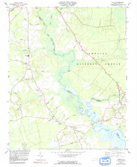
1984 Map of Stella
USGS Topo · Published 1991About this map
The White Oak River defines the landscape of this coastal plain region, serving as the boundary between Jones, Carteret, and Onslow counties. Small agricultural and riverside settlements like Stella and Silverdale are connected by a network of rural roads and family-named landmarks. The presence of the Croatan National Forest and the northern edge of Camp Lejeune indicate a landscape shaped by both federal conservation and military use during the late twentieth century. Genealogists will find a wealth of local landmarks, including St Stephens Ch, Davis Chapel, and the Tabernacle Sch. Industrial and transportation features such as the Seaboard railroad line in the northwest corner and a Quarry near the Jones County line provide evidence of the local economy. From the wetlands of Black Swamp to the river landing at Elm Landing, the map records a specific era of coastal North Carolina life before significant modern development altered these small communities.
Find a feature on this map
43 named features on this map. Tap any name to fly to it.
Don’t see what you’re looking for? This feature index may not catch every label — zoom into the map to look around manually.
Map Details
Editions of this 1984 Stella Map
2 editions found
Other maps of this area

1942 · Maysville
USGS Topo · 1:62,500

1942 · Swansboro
USGS Topo · 1:62,500

1943 · Jacksonville
USGS Topo · 1:62,500

1948 · Maysville
USGS Topo · 1:62,500

1948 · Swansboro
USGS Topo · 1:62,500

1948 · New River
USGS Topo · 1:62,500

1952 · Hubert
USGS Topo · 1:24,000

1952 · Camp Lejeune
USGS Topo · 1:24,000

1952 · Swansboro
USGS Topo · 1:24,000

1953 · Beaufort
USGS Topo · 1:250,000