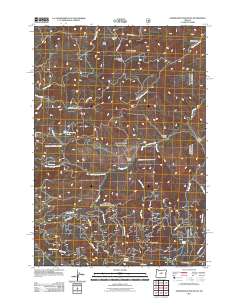
2011 Map of Stephenson Mountain
USGS Topo · Published 2011About this map
Stephenson Mountain and the high ridges of the Ochoco Mountains define this section of central Oregon. The landscape is marked by remote outposts such as Ludwick Cabin and the Old Stephenson Ranch, providing a window into the region's ranching and forestry history. Water sources are vital in this terrain, as evidenced by numerous named springs including Bear Spring, Dodds Spring, and Jackalope Spring. A network of drainage systems like North Fork Bear Creek and Stephenson Creek carve through the topography, leading to notable landmarks like Red Rock Pass. Forest service roads such as Old Burma Rd and Rail Creek Rd crisscross the area, connecting high points like Tracy Mountain and Cougar Butte with the southern corridor through Ochoco Pass.
Find a feature on this map
36 named features on this map. Tap any name to fly to it.
Don’t see what you’re looking for? This feature index may not catch every label — zoom into the map to look around manually.
Map Details
Editions of this 2011 Stephenson Mountain Map
This is the sole edition of this map. No revisions or reprints were ever made.
Other maps of this area

1926 · Mitchell
USGS Topo · 1:125,000

1948 · Ochoco Reservoir
USGS Topo · 1:62,500

1950 · Ochoco Reservoir
USGS Topo · 1:62,500

1951 · Lookout Mtn
USGS Topo · 1:62,500

1955 · Bend
USGS Topo · 1:250,000

1957 · Bend
USGS Topo · 1:250,000

1958 · Bend
USGS Topo · 1:250,000

1968 · Horse Heaven Creek
USGS Topo · 1:24,000

1968 · Painted Hills
USGS Topo · 1:24,000

1968 · Lawson Mtn
USGS Topo · 1:24,000