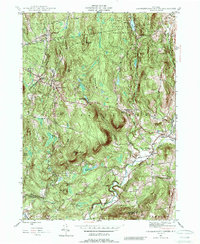
1945 Map of Stephentown Center
USGS Topo · Published 1989About this map
Stephentown Center and the surrounding hamlets of Rensselaer County are captured here just as post-war modernization began to touch this upland landscape. The terrain is defined by a series of prominent peaks and ridges, including Pomeroy Hill, Buckwheat Hill, and Turner Mountain, the latter of which features a Turner Airway Beacon for early aviation navigation. The rural character of the mid-1940s is evident in the cluster of small settlements like Dunham Hollow and Garfield, where local life centered around landmarks such as Sacred Heart Church and several family burying grounds, including Hillside Cem and Presbyterian Hill Cem. To the north, the Capital District Forest Game Refuge and the Seven Hill Fire Tower represent early 20th-century conservation and fire lookouts. Water features like Kinderhook Creek and Black River Pond drain these highlands, which straddle the border of Lebanon and the Rensselaer and Columbia county line.
Find a feature on this map
34 named features on this map. Tap any name to fly to it.
Don’t see what you’re looking for? This feature index may not catch every label — zoom into the map to look around manually.
Map Details
Editions of this 1945 Stephentown Center Map
4 editions found
Other maps of this area

1888 · Berlin
USGS Topo · 1:62,500

1888 · Pittsfield
USGS Topo · 1:62,500

1890 · Pittsfield
USGS Topo · 1:62,500

1890 · Berlin
USGS Topo · 1:62,500

1893 · Troy
USGS Topo · 1:62,500

1893 · Pittsfield
USGS Topo · 1:62,500

1894 · Berlin
USGS Topo · 1:62,500

1894 · Pittsfield
USGS Topo · 1:62,500

1895 · Troy
USGS Topo · 1:62,500

1897 · Pittsfield
USGS Topo · 1:62,500