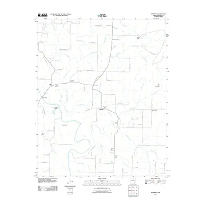
2011 Map of Steprock
USGS Topo · Published 2011About this map
Little Red River meanders through the central terrain of White County, anchoring a landscape of rural hamlets and family-held acreage. The settlement of Steprock serves as a local hub, anchored by the Steprock Post Office and connected to neighboring Sunnydale and Bare Stone by a network of named country roads such as King Mountain Rd and Landis Rd.
Find a feature on this map
87 named features on this map. Tap any name to fly to it.
Don’t see what you’re looking for? This feature index may not catch every label — zoom into the map to look around manually.
Map Details
Editions of this 2011 Steprock Map
This is the sole edition of this map. No revisions or reprints were ever made.
Other maps of this area

1890 · Batesville
USGS Topo · 1:125,000

1891 · Batesville
USGS Topo · 1:125,000

1935 · Bald Knob
USGS Topo · 1:62,500

1953 · Memphis
USGS Topo · 1:250,000

1956 · Memphis
USGS Topo · 1:250,000

1962 · Pangburn
USGS Topo · 1:24,000

1962 · Letona
USGS Topo · 1:24,000

1965 · Pleasant Plains
USGS Topo · 1:24,000
1965 · Bald Knob
USGS Topo · 1:24,000
1965 · Judsonia
USGS Topo · 1:24,000