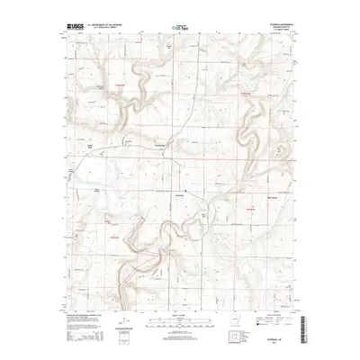
2014 Map of Steprock
USGS Topo · Published 2014About this map
Little Red River defines the lower geography of this section of White County, cutting through the lowlands of Wells Bottom and under the Dewey Bridge. The landscape transitions from the flat river valley to more complex terrain marked by elevations like Tater Hill, Round Mtn, and Flat Top Mtn. Small rural communities such as Steprock, Sunnydale, and Bare Stone are connected by a network of local roads and cattle drives. For family historians, several burial grounds are scattered throughout the region, including Philadelphia Cem and Morris Cem. The numerous creeks and branches, such as Fourteenmile Cr and Tenmile Cr, illustrate the drainage patterns that have historically shaped the agricultural and residential development of these Arkansas townships.
Find a feature on this map
93 named features on this map. Tap any name to fly to it.
Don’t see what you’re looking for? This feature index may not catch every label — zoom into the map to look around manually.
Map Details
Editions of this 2014 Steprock Map
This is the sole edition of this map. No revisions or reprints were ever made.
Other maps of this area

1890 · Batesville
USGS Topo · 1:125,000

1891 · Batesville
USGS Topo · 1:125,000

1935 · Bald Knob
USGS Topo · 1:62,500

1953 · Memphis
USGS Topo · 1:250,000

1956 · Memphis
USGS Topo · 1:250,000

1962 · Pangburn
USGS Topo · 1:24,000

1962 · Letona
USGS Topo · 1:24,000

1965 · Pleasant Plains
USGS Topo · 1:24,000
1965 · Bald Knob
USGS Topo · 1:24,000
1965 · Judsonia
USGS Topo · 1:24,000