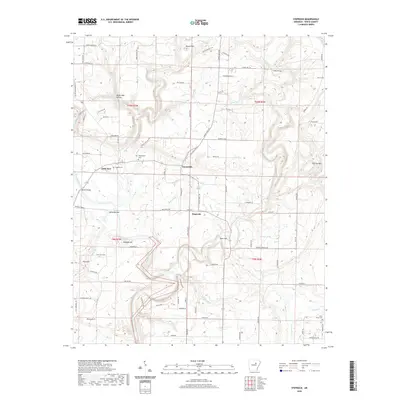
2020 Map of Steprock
USGS Topo · Published 2020About this map
Steprock and the surrounding White County landscape are defined by the winding course of the Little Red River as it moves through the hills of north-central Arkansas. The area is characterized by a network of creeks, including Fourteenmile Cr, Tenmile Cr, and Cypress Cr, which have shaped the local topography into distinct features like White Oak Hollow and Wildcat Hill. The settlement pattern follows these watercourses and ridgelines, with the small community of Sunnydale situated between the elevations of Round Mtn and Tater Hill.
Find a feature on this map
134 named features on this map. Tap any name to fly to it.
Don’t see what you’re looking for? This feature index may not catch every label — zoom into the map to look around manually.
Map Details
Editions of this 2020 Steprock Map
This is the sole edition of this map. No revisions or reprints were ever made.
Other maps of this area

1890 · Batesville
USGS Topo · 1:125,000

1891 · Batesville
USGS Topo · 1:125,000

1935 · Bald Knob
USGS Topo · 1:62,500

1953 · Memphis
USGS Topo · 1:250,000

1956 · Memphis
USGS Topo · 1:250,000

1962 · Pangburn
USGS Topo · 1:24,000

1962 · Letona
USGS Topo · 1:24,000

1965 · Pleasant Plains
USGS Topo · 1:24,000
1965 · Bald Knob
USGS Topo · 1:24,000
1965 · Judsonia
USGS Topo · 1:24,000