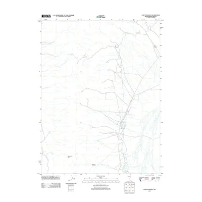
2012 Map of Steptoe Ranch
USGS Topo · Published 2012About this map
Steptoe Ranch serves as the focal point for this high-desert landscape in White Pine County, where water sources dictate the pattern of human presence. Situated along Co Rd 77, the ranch is surrounded by a network of vital water features including Campbell Ranch Springs and Duck Creek. The geography is defined by seasonal drainages and topographic landmarks such as Molleson Gap and Dry Canyon, which channel the limited moisture of the Great Basin. To the south, Malleson Spring and Grass Springs indicate the continued importance of these isolated water points for livestock and land management. The presence of Combs Creek and various named springs like Mud Spring suggests a reliance on scattered hydrologic resources within the arid basins and ranges that characterize this part of Nevada.
Find a feature on this map
14 named features on this map. Tap any name to fly to it.
Don’t see what you’re looking for? This feature index may not catch every label — zoom into the map to look around manually.
Map Details
Editions of this 2012 Steptoe Ranch Map
This is the sole edition of this map. No revisions or reprints were ever made.
Other maps of this area

1952 · Ely
USGS Topo · 1:125,000

1956 · Ely
USGS Topo · 1:250,000

1958 · McGill
USGS Topo · 1:24,000

1958 · McGill
USGS Topo · 1:62,500

1959 · Ely
USGS Topo · 1:250,000

1959 · Reipetown
USGS Topo · 1:62,500
1962 · Hunter Point
USGS Topo · 1:24,000

1963 · Ely
USGS Topo · 1:250,000

1979 · Mt. Hamilton
USGS Topo · 1:100,000
1982 · Monte Neva Hot Springs
USGS Topo · 1:24,000