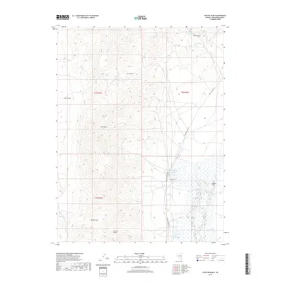
2018 Map of Steptoe Ranch
USGS Topo · Published 2018About this map
The high-elevation ranching country of White Pine County is defined by the transition between the Egan Range and the surrounding basins. Steptoe Ranch sits as a primary landmark at the foot of the mountains, supported by a network of water sources such as Campbell Ranch Springs and Grass Springs. The landscape is carved by dramatic relief, visible in the steep grades of Water Canyon and Dry Canyon, while Molleson Gap provides a natural passage through the ridgeline. To the west, the map captures a portion of Butte Valley, contrasted by the eastern expanse of Steptoe Valley. This 2018 survey detail illustrates the vital importance of seasonal and permanent water in the Great Basin, where named features like Malleson Spring and Mud Spring indicate the essential points for livestock and land management in a dry environment.
Find a feature on this map
20 named features on this map. Tap any name to fly to it.
Don’t see what you’re looking for? This feature index may not catch every label — zoom into the map to look around manually.
Map Details
Editions of this 2018 Steptoe Ranch Map
This is the sole edition of this map. No revisions or reprints were ever made.
Other maps of this area

1952 · Ely
USGS Topo · 1:125,000

1956 · Ely
USGS Topo · 1:250,000

1958 · McGill
USGS Topo · 1:24,000

1958 · McGill
USGS Topo · 1:62,500

1959 · Ely
USGS Topo · 1:250,000

1959 · Reipetown
USGS Topo · 1:62,500
1962 · Hunter Point
USGS Topo · 1:24,000

1963 · Ely
USGS Topo · 1:250,000

1979 · Mt. Hamilton
USGS Topo · 1:100,000
1982 · Monte Neva Hot Springs
USGS Topo · 1:24,000