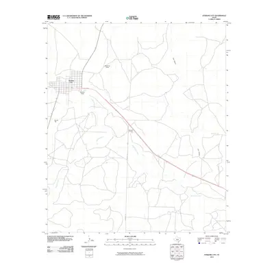
2010 Map of Sterling City
USGS Topo · Published 2010About this map
Sterling City serves as the focal point of this West Texas landscape, situated at the confluence of several significant watercourses and ephemeral drainage paths. The community's grid layout is framed by Sterling Creek to the south and the winding path of the North Concho River, which meanders southeastward across the quadrangle. The hydrology of the area is defined by features like Mackenzie Draw and Bodcaw Draw, illustrating the arid region's reliance on these natural drainage basins. To the southeast of the main settlement, Montvale Cemetery provides a tangible link for genealogists and local historians researching the legacy of early residents in Sterling County. The terrain is marked by distinctive elevations such as Round Top and the geological indentation of Cox Hollow, while rural travel is facilitated by corridors like Sherwood Ln and China Valley Ln.
Find a feature on this map
10 named features on this map. Tap any name to fly to it.
Don’t see what you’re looking for? This feature index may not catch every label — zoom into the map to look around manually.
Map Details
Editions of this 2010 Sterling City Map
This is the sole edition of this map. No revisions or reprints were ever made.
Other maps of this area

1954 · San Angelo
USGS Topo · 1:250,000

1958 · San Angelo
USGS Topo · 1:250,000

1963 · Cumbie Draw
USGS Topo · 1:24,000

1963 · Cumbie Draw NE
USGS Topo · 1:24,000

1965 · San Angelo
USGS Topo · 1:250,000

1972 · Sterling City
USGS Topo · 1:24,000

1972 · Dog Creek NE
USGS Topo · 1:24,000

1972 · Broome
USGS Topo · 1:24,000
1972 · Crawford Slide
USGS Topo · 1:24,000
1972 · Sterling City NW
USGS Topo · 1:24,000