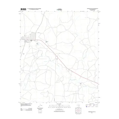
2012 Map of Sterling City
USGS Topo · Published 2012About this map
Sterling City serves as the focal point for this West Texas landscape, positioned at the intersection of local routes like 1st Ave and Water St. The town's grid is bounded by the winding course of the N Concho River, which cuts southeast across the terrain. This USGS topographic study shows a region defined by its drainage patterns, where significant seasonal features like Mackenzie Draw and Bodcaw Draw converge toward the river valley. The map is particularly useful for local history and genealogy, noting the location of Montvale Cem along the highway southeast of the main town site. High points like Round Top rise above the surrounding flats, while the southern portion of the quadrangle is marked by the rugged geography of Cox Hollow and the meandering Sterling Cr.
Find a feature on this map
20 named features on this map. Tap any name to fly to it.
Don’t see what you’re looking for? This feature index may not catch every label — zoom into the map to look around manually.
Map Details
Editions of this 2012 Sterling City Map
This is the sole edition of this map. No revisions or reprints were ever made.
Other maps of this area

1954 · San Angelo
USGS Topo · 1:250,000

1958 · San Angelo
USGS Topo · 1:250,000

1963 · Cumbie Draw
USGS Topo · 1:24,000

1963 · Cumbie Draw NE
USGS Topo · 1:24,000

1965 · San Angelo
USGS Topo · 1:250,000

1972 · Sterling City
USGS Topo · 1:24,000

1972 · Dog Creek NE
USGS Topo · 1:24,000

1972 · Broome
USGS Topo · 1:24,000
1972 · Crawford Slide
USGS Topo · 1:24,000
1972 · Sterling City NW
USGS Topo · 1:24,000