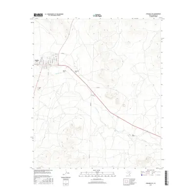
2016 Map of Sterling City
USGS Topo · Published 2016About this map
Sterling City sits at the confluence of arid plains and rugged drainage networks, serving as a primary hub for this West Texas landscape. The town's grid is meticulously detailed, showing the layout of streets from 1st St up to 12th St, and north-south thoroughfares like Main St and Washington St. This community organization contrasts with the surrounding natural topography, where the N Concho River and Sterling Cr have carved deep courses through the terrain. Evidence of early settlement and regional history is preserved at the Montvale Cem, located southeast of the town center along the highway. To the west, the distinctive prominence of Round Top stands as a landmark above the valley floor. The map also traces the significant local hydrology of the Edwards Plateau, including the winding paths of Bodcaw Draw, Mackenzie Draw, and Cox Hollow, illustrating how water shaped the cattle-ranching territory of Sterling County.
Find a feature on this map
33 named features on this map. Tap any name to fly to it.
Don’t see what you’re looking for? This feature index may not catch every label — zoom into the map to look around manually.
Map Details
Editions of this 2016 Sterling City Map
This is the sole edition of this map. No revisions or reprints were ever made.
Other maps of this area

1954 · San Angelo
USGS Topo · 1:250,000

1958 · San Angelo
USGS Topo · 1:250,000

1963 · Cumbie Draw
USGS Topo · 1:24,000

1963 · Cumbie Draw NE
USGS Topo · 1:24,000

1965 · San Angelo
USGS Topo · 1:250,000

1972 · Sterling City
USGS Topo · 1:24,000

1972 · Dog Creek NE
USGS Topo · 1:24,000

1972 · Broome
USGS Topo · 1:24,000
1972 · Crawford Slide
USGS Topo · 1:24,000
1972 · Sterling City NW
USGS Topo · 1:24,000