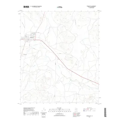
2019 Map of Sterling City
USGS Topo · Published 2019About this map
Sterling City serves as the focal point of this West Texas landscape, situated at the confluence of several significant drainage systems. The town's grid is well-defined, with streets ranging from 1st St to 12th St and thoroughfares like Lee Ave providing access to local services, including the central Po. The surrounding terrain is characterized by the winding path of the N Concho River and its tributaries, such as Sterling Cr, Mackenzie Draw, and Bodcaw Draw. These waterways have carved distinct features into the Edwards Plateau, including Cox Hollow and the prominent Round Top. South of the main settlement, Montvale Cem sits along the highway, offering a point of interest for genealogists tracing early families in Sterling County. The network of rural routes, including Co Rd 300-P and Sherwood Ln, illustrates the connectivity between the ranching highlands and the valley floor.
Find a feature on this map
26 named features on this map. Tap any name to fly to it.
Don’t see what you’re looking for? This feature index may not catch every label — zoom into the map to look around manually.
Map Details
Editions of this 2019 Sterling City Map
This is the sole edition of this map. No revisions or reprints were ever made.
Other maps of this area

1954 · San Angelo
USGS Topo · 1:250,000

1958 · San Angelo
USGS Topo · 1:250,000

1963 · Cumbie Draw
USGS Topo · 1:24,000

1963 · Cumbie Draw NE
USGS Topo · 1:24,000

1965 · San Angelo
USGS Topo · 1:250,000

1972 · Sterling City
USGS Topo · 1:24,000

1972 · Dog Creek NE
USGS Topo · 1:24,000

1972 · Broome
USGS Topo · 1:24,000
1972 · Crawford Slide
USGS Topo · 1:24,000
1972 · Sterling City NW
USGS Topo · 1:24,000