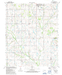
1991 Map of Sterling
USGS Topo · Published 1991About this map
Sterling serves as the primary hub in this corner of southwestern Oklahoma, where the prairie landscape is defined by a dense network of energy extraction. Numerous Gas Wells and Oil Wells are scattered across the terrain, culminating in a concentrated Oil Field in the southern sections. This industrial footprint sits atop a rural foundation of established homesteads and spiritual centers, such as Midway Ch and Denton Ch.
Find a feature on this map
17 named features on this map. Tap any name to fly to it.
Don’t see what you’re looking for? This feature index may not catch every label — zoom into the map to look around manually.
Map Details
Editions of this 1991 Sterling Map
This is the sole edition of this map. No revisions or reprints were ever made.
Other maps of this area

1946 · Lawton
USGS Topo · 1:62,500

1949 · Arbuckle Hill
USGS Topo · 1:24,000

1949 · Cement
USGS Topo · 1:62,500

1949 · Elgin
USGS Topo · 1:24,000

1949 · Nellie
USGS Topo · 1:62,500

1955 · Lawton
USGS Topo · 1:250,000

1956 · Sterling
USGS Topo · 1:24,000

1956 · Ninemile Creek
USGS Topo · 1:24,000

1956 · Fletcher
USGS Topo · 1:24,000

1956 · Arbuckle Hill
USGS Topo · 1:24,000