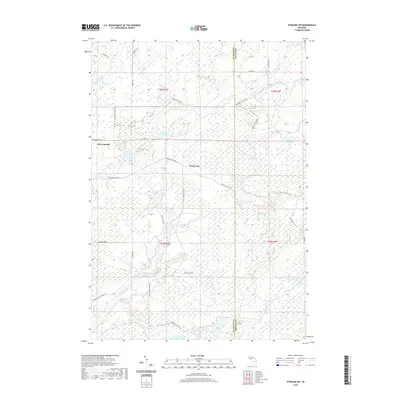
2019 Map of Sterling SW
USGS Topo · Published 2019About this map
Bowmanville and the uniquely named Hard Luck anchor this map of north-central Michigan, where the landscape is defined by the winding course of the Molasses River. The area is a dense network of forest passages and service tracks, including the descriptively titled Lame Duck Truck Trl and Mosquito Alley Truck Trl. This region, crossing the boundary of Gladwin and Arenac Counties, showcases a typical northern Michigan wetland and timber environment. Large marshy tracts like Bentley Marsh and the headwaters of Wells Cr dominate the eastern reaches, while primary access is maintained via routes such as Secord Dam Rd and Bomanville Rd. The map illustrates a modern state of the wilderness-fringe settlements, where seasonal use and forest management drive the local geography.
Find a feature on this map
25 named features on this map. Tap any name to fly to it.
Don’t see what you’re looking for? This feature index may not catch every label — zoom into the map to look around manually.
Map Details
Editions of this 2019 Sterling SW Map
This is the sole edition of this map. No revisions or reprints were ever made.
Other maps of this area

1954 · Traverse City
USGS Topo · 1:250,000

1954 · Midland
USGS Topo · 1:250,000

1958 · Traverse City
USGS Topo · 1:250,000

1958 · Midland
USGS Topo · 1:250,000

1959 · Midland
USGS Topo · 1:250,000

1966 · Midland
USGS Topo · 1:250,000
1967 · Mount Forest
USGS Topo · 1:24,000

1968 · Sterling
USGS Topo · 1:24,000
1968 · Skidway Lake
USGS Topo · 1:24,000

1968 · Sterling SW
USGS Topo · 1:24,000