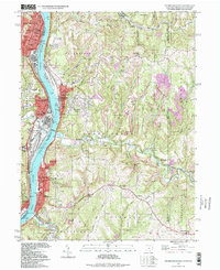
1997 Map of Steubenville East
USGS Topo · Published 1999About this map
The Ohio River corridor serves as the industrial and social backbone for this region where Ohio, West Virginia, and Pennsylvania meet. The riverfront is densely developed with infrastructure like the Wabash Bridge and municipal centers in Steubenville, Follansbee, and Wellsburg. Beyond the immediate banks, the terrain rises into ridges such as Mahan Ridge and Montgomery Hill, where small settlements and rural landmarks persist. The landscape is a mix of urban density and extractive industry, evidenced by the numerous strip mines that punctuate the hillsides. Institutional life is well-documented through a network of parochial schools, including St Stanislaus Sch and St Agnes Sch, alongside several community hubs like the Home for the Aged. This mid-to-late 20th-century landscape reveals the deeply etched patterns of coal mining and river-borne commerce that shaped these valley communities.
Find a feature on this map
92 named features on this map. Tap any name to fly to it.
Don’t see what you’re looking for? This feature index may not catch every label — zoom into the map to look around manually.
Map Details
Editions of this 1997 Steubenville East Map
This is the sole edition of this map. No revisions or reprints were ever made.
Other maps of this area

1902 · Wheeling
USGS Topo · 1:62,500

1904 · Steubenville
USGS Topo · 1:62,500

1904 · Burgettstown
USGS Topo · 1:62,500

1906 · Burgettstown
USGS Topo · 1:62,500

1907 · Claysville
USGS Topo · 1:62,500

1935 · Wheeling
USGS Topo · 1:62,500

1935 · Steubenville
USGS Topo · 1:62,500

1942 · Wheeling
USGS Topo · 1:62,500

1942 · Steubenville
USGS Topo · 1:62,500

1951 · Canton
USGS Topo · 1:250,000