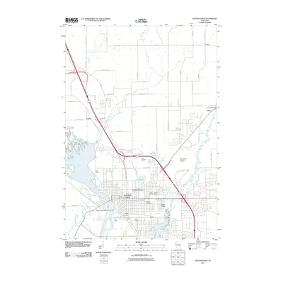
2010 Map of Stevens Point
USGS Topo · Published 2010About this map
Stevens Point is defined by its deep relationship with the Wisconsin River and the Plover River, which converge in this central Wisconsin landscape. By the early 21st century, the city had established itself as a significant educational and municipal hub, anchored by the University of Wisconsin - Stevens Point Campus and the Stevens Point Post Office. The residential and commercial grid is punctuated by numerous historical burial grounds, including Saint Josephs Cemetery, Guardian Angel Cemetery, and Forest Cemetery, which offer valuable points of reference for local genealogists. North of the city, the landscape transitions into a network of creeks and small settlements like Casimir and Torun. Significant infrastructure is visible at the Stevens Point Municipal Airport and the Jordan 1905-39 Dam, marking the intersection of the region's hydraulic history and modern transport.
Find a feature on this map
60 named features on this map. Tap any name to fly to it.
Don’t see what you’re looking for? This feature index may not catch every label — zoom into the map to look around manually.
Map Details
Editions of this 2010 Stevens Point Map
This is the sole edition of this map. No revisions or reprints were ever made.
Other maps of this area

1955 · Rosholt
USGS Topo · 1:48,000

1955 · Green Bay
USGS Topo · 1:250,000

1956 · Stevens Point
USGS Topo · 1:48,000

1957 · Amherst
USGS Topo · 1:48,000

1957 · Whiting
USGS Topo · 1:48,000

1969 · Arnott
USGS Topo · 1:24,000

1969 · Rosholt NW
USGS Topo · 1:24,000
1969 · Polonia
USGS Topo · 1:24,000

1970 · Stevens Point
USGS Topo · 1:24,000
1970 · Rocky Run
USGS Topo · 1:24,000