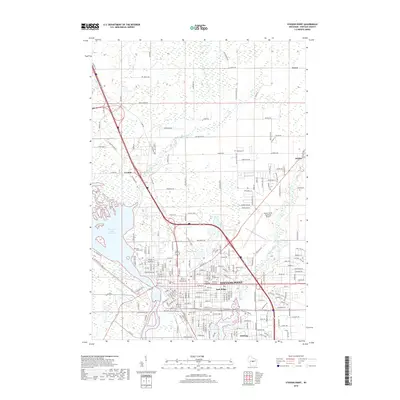
2018 Map of Stevens Point
USGS Topo · Published 2018About this map
The Wisconsin River Flowage and the southward-flowing Wisconsin River serve as the dominant geographical anchors for the city of Stevens Point. This 2018 survey reveals a landscape where suburban expansion meets legacy industrial and water features, including the Soo Line rail corridors and the Plover River as it feeds into McDill Pond. The map detail provides a high-resolution look at the cluster of faith-based landmarks in the central city, such as Saint Peters Cem, Saint Josephs Cem, and Guardian Angel Cem, which are vital for genealogical research in this region. North of the city, the terrain transitions into the wetlands of Dewey Marsh and the residential clusters of Casimir and Torun. Smaller water bodies like Lake Joanis and Johns Lake dot the eastern side of the river, while the Whiting and Park Ridge enclaves illustrate the local jurisdictional complexity within this Portage County hub.
Find a feature on this map
205 named features on this map. Tap any name to fly to it.
Don’t see what you’re looking for? This feature index may not catch every label — zoom into the map to look around manually.
Map Details
Editions of this 2018 Stevens Point Map
This is the sole edition of this map. No revisions or reprints were ever made.
Other maps of this area

1955 · Rosholt
USGS Topo · 1:48,000

1955 · Green Bay
USGS Topo · 1:250,000

1956 · Stevens Point
USGS Topo · 1:48,000

1957 · Amherst
USGS Topo · 1:48,000

1957 · Whiting
USGS Topo · 1:48,000

1969 · Arnott
USGS Topo · 1:24,000

1969 · Rosholt NW
USGS Topo · 1:24,000
1969 · Polonia
USGS Topo · 1:24,000

1970 · Stevens Point
USGS Topo · 1:24,000
1970 · Rocky Run
USGS Topo · 1:24,000