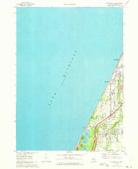
1970 Map of Stevensville
USGS Topo · Published 1973About this map
Lake Michigan dominates the western horizon of this coastal Berrien County landscape, where the shoreline is defined by a sequence of dunes and the Grand Mere Lakes. Inland, the village of Stevensville serves as a primary hub, situated between the Chesapeake and Ohio railroad tracks and the prominent Red Arrow Hwy. The map reveals a suburbanizing character in the early 1970s, with residential developments stretching north through Shoreham and Glen Lord. Local life is anchored by community landmarks such as the Stevensville Cem, Stewart Sch, and a mid-century Drive-in Theater. To the south, the preservation of natural spaces is evident in North Lake Park and the adjacent Township Park, which protect the unique hydrology where Hickory Creek winds through the eastern lowlands toward the lake.
Find a feature on this map
21 named features on this map. Tap any name to fly to it.
Don’t see what you’re looking for? This feature index may not catch every label — zoom into the map to look around manually.
Map Details
Editions of this 1970 Stevensville Map
2 editions found
Other maps of this area

1927 · Niles
USGS Topo · 1:62,500

1927 · Benton Harbor
USGS Topo · 1:62,500

1930 · Three Oaks
USGS Topo · 1:62,500

1930 · Benton Harbor
USGS Topo · 1:62,500

1930 · Niles
USGS Topo · 1:62,500

1943 · Niles
USGS Topo · 1:62,500

1944 · Three Oaks
USGS Topo · 1:62,500

1953 · Chicago
USGS Topo · 1:250,000

1957 · Chicago
USGS Topo · 1:250,000

1958 · Racine
USGS Topo · 1:250,000