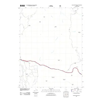
2011 Map of Steves Mountain
USGS Topo · Published 2011About this map
Steves Mountain and Cedar Mountain anchor this high-elevation landscape in Sevier County, where deep canyons and flat-topped basins define the drainage patterns of central Utah. The southern portion of the quadrangle is dominated by the winding course of Salina Creek, which runs parallel to the modern transportation corridor and is joined by the Gooseberry Creek system near Gooseberry Valley. The naming of features like Beanies Hole, Browns Hole, and Dead Horse Canyon reflects a legacy of livestock grazing and early exploration in the Fishlake National Forest area. Transportation is largely defined by the Water Hollow Rd and Gooseberry Rd, which provide access to remote landmarks such as Anthony Flat and Steves Pass. The contrast between the expansive Steves Basin and the sharp relief of the Sawtooth illustrates the varied geological character of the Wasatch Plateau's southern reaches.
Find a feature on this map
32 named features on this map. Tap any name to fly to it.
Don’t see what you’re looking for? This feature index may not catch every label — zoom into the map to look around manually.
Map Details
Editions of this 2011 Steves Mountain Map
This is the sole edition of this map. No revisions or reprints were ever made.
Other maps of this area

1885 · Manti
USGS Topo · 1:250,000

1885 · Fish Lake
USGS Topo · 1:250,000

1895 · Manti
USGS Topo · 1:250,000

1896 · Fish Lake
USGS Topo · 1:250,000

1956 · Salina
USGS Topo · 1:250,000

1956 · Price
USGS Topo · 1:250,000

1960 · Price
USGS Topo · 1:250,000

1960 · Salina
USGS Topo · 1:250,000

1962 · Salina
USGS Topo · 1:250,000

1962 · Price
USGS Topo · 1:250,000