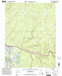
2001 Map of Steves Mountain
USGS Topo · Published 2003About this map
Fishlake National Forest encompasses the majority of this Sevier County landscape, where the Cedar Mountains define the high terrain. The geography is marked by significant topographical landmarks such as Steves Mountain, Steves Pass, and Steves Basin. In the southern reaches, Salina Creek carves a deep valley followed by the local road network, showing evidence of early resource extraction with labeled Mines, a Prospect, and a Tunnel near Coal Hollow.
Find a feature on this map
45 named features on this map. Tap any name to fly to it.
Don’t see what you’re looking for? This feature index may not catch every label — zoom into the map to look around manually.
Map Details
Editions of this 2001 Steves Mountain Map
This is the sole edition of this map. No revisions or reprints were ever made.
Other maps of this area

1885 · Manti
USGS Topo · 1:250,000

1885 · Fish Lake
USGS Topo · 1:250,000

1895 · Manti
USGS Topo · 1:250,000

1896 · Fish Lake
USGS Topo · 1:250,000

1956 · Salina
USGS Topo · 1:250,000

1956 · Price
USGS Topo · 1:250,000

1960 · Price
USGS Topo · 1:250,000

1960 · Salina
USGS Topo · 1:250,000

1962 · Salina
USGS Topo · 1:250,000

1962 · Price
USGS Topo · 1:250,000