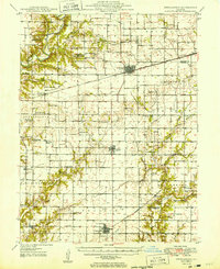
1949 Map of Stewardson
USGS Topo · Published 1949About this map
The Kaskaskia River and Little Wabash River dominate the drainage of this central Illinois landscape, where the New York Chicago and St Louis and Central Illinois railroads intersect the grid of farming townships. This 1949 survey documents a deeply rooted rural society centered around Stewardson, Strasburg, and Windsor. The map reveals a dense network of country institutions, including family-named landmarks like the Rincker Cem and Bruce Cem, alongside numerous local schools such as Wabash Sch and Hiatt Sch. Several oil wells are noted in Richland and Ash Grove townships, indicating the mid-century energy development that supplemented the region's agricultural base. Smaller rail stops like Trowbridge and Gays provide a look at the commercial transport points that once served these dispersed neighborhoods.
Find a feature on this map
68 named features on this map. Tap any name to fly to it.
Don’t see what you’re looking for? This feature index may not catch every label — zoom into the map to look around manually.
Map Details
Editions of this 1949 Stewardson Map
2 editions found

Other maps of this area

1934 · Mattoon
USGS Topo · 1:62,500

1935 · Arcola
USGS Topo · 1:48,000

1935 · Sullivan
USGS Topo · 1:48,000

1937 · Mattoon
USGS Topo · 1:62,500

1940 · Sullivan
USGS Topo · 1:62,500

1940 · Arcola
USGS Topo · 1:62,500

1941 · St. Elmo
USGS Topo · 1:62,500

1942 · Shelbyville
USGS Topo · 1:62,500

1945 · St. Elmo
USGS Topo · 1:62,500

1946 · Shelbyville
USGS Topo · 1:62,500