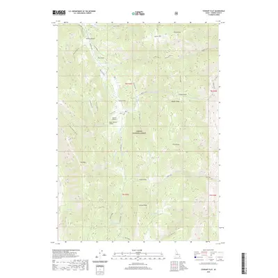
2020 Map of Stewart Flat
USGS Topo · Published 2020About this map
Caribou National Forest dominates this high-altitude landscape in the southeastern corner of Idaho. The terrain is defined by a series of parallel ridgelines and drainages, most notably the Webster Range and the prominent Draney Peak in the northeast. Water sources are critical in this environment, evidenced by named features like Bell Spring, Hill Spring, and Bone Pine Spring which dot the draws leading toward the Diamond Creek valley.
Find a feature on this map
44 named features on this map. Tap any name to fly to it.
Don’t see what you’re looking for? This feature index may not catch every label — zoom into the map to look around manually.
Map Details
Editions of this 2020 Stewart Flat Map
This is the sole edition of this map. No revisions or reprints were ever made.
Other maps of this area

1911 · Slug Creek
USGS Topo · 1:62,500

1915 · Freedom
USGS Topo · 1:62,500

1915 · Crow Creek
USGS Topo · 1:62,500

1915 · Lanes Creek
USGS Topo · 1:62,500

1949 · Stewart Flat
USGS Topo · 1:24,000

1949 · Dry Valley
USGS Topo · 1:24,000

1949 · Snowdrift Mountain
USGS Topo · 1:24,000
1951 · Upper Valley
USGS Topo · 1:24,000

1951 · Stewart Flat
USGS Topo · 1:24,000
1951 · Dry Valley
USGS Topo · 1:24,000