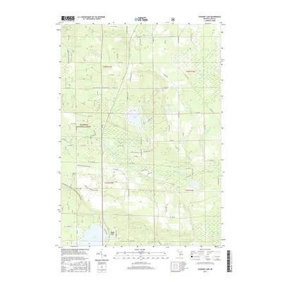
2017 Map of Stewart Lake
USGS Topo · Published 2017About this map
Manistee National Forest dominates this section of Lake County, where a dense network of secondary roads and forest trails navigates a landscape defined by glacial hydrology. The small settlement of Peacock and the nearby Peacock Cem serve as primary points of interest for genealogists tracing local families in Eden Township. Water is the defining characteristic of the terrain, with the Little Manistee River winding through the center, flanked by extensive wetlands like Syers Swamp and Baldwin-Luther Swamp. Small kettle lakes such as Stewart Lake, Syers Lake, and Wolf Lake are scattered throughout the forest, connected by minor tributaries including Twin Cr and S Big Twin Cr. This 2017 survey reflects the area's modern character as a managed wilderness, where the grid of section lines and named forest roads like N Merrillville Rd and N M 37 provide access to the marshes and timberlands.
Find a feature on this map
77 named features on this map. Tap any name to fly to it.
Don’t see what you’re looking for? This feature index may not catch every label — zoom into the map to look around manually.
Map Details
Editions of this 2017 Stewart Lake Map
This is the sole edition of this map. No revisions or reprints were ever made.
Other maps of this area

1931 · Baldwin NW
USGS Topo · 1:31,680

1931 · Baldwin NE
USGS Topo · 1:31,680

1932 · Chase NW
USGS Topo · 1:31,680

1933 · Peacock SE
USGS Topo · 1:31,680

1933 · Peacock SW
USGS Topo · 1:31,680

1933 · Peacock NE
USGS Topo · 1:31,680

1933 · Luther SW
USGS Topo · 1:31,680

1933 · Luther NW
USGS Topo · 1:31,680

1933 · Peacock NW
USGS Topo · 1:31,680

1954 · Traverse City
USGS Topo · 1:250,000